HOT

12Apr

On being a HOT Board Member

After 4 years, today my last day as a Board Member of Humanitarian OpenStreetMap Team. We have annual board elections announced at our Annual General Meeting in a few short hours. During my time on HOT’s Board, I served as a Member-at-Large, Secretary and President. Serving on the HOT board has been challenging and rewarding as the NGO has grown in leaps and bounds. It has been an honour to be part of that journey with fellow board members, members, staff, community allies, donors, and supporters. (Thank you.)

The Humanitarian OpenStreetMap Team (HOT) applies the principles of open source and open data sharing for humanitarian response and economic development.

Being a Board Member for a small NGO can be a serious commitment. HOT’s Board is transitioning from operations to a strategic board. It is something that every open source community does over time. To support this change, the board, staff and membership have learned much about organizational development, governance and fundraising. This has taken substantial leadership from two Executive Directors (Kate Chapman and Tyler Radford), staff, and many fellow Board Members. Some of the ‘back office support’ that the HOT board provided previously are now staff and community roles. (One example of organizational development, is the Board Primer that I curated.)

Honestly, serving HOT changed my life and I am thankful for all the experiences. And, I am thankful for all the amazing people with whom I met or collaborated.

HOT Activation Sprint

What being on the Board taught me

We all have our goals – personal and career.

Being on the HOT Board taught me to be a better leader. There are so many proud moments as I reflect – watching and supporting leaders, learning about all the amazing projects and advocacy work, and sharing the HOT story in many public forums, like this Datashift article. I helped build and support a growing NGO. HOT truly inspires me, as do the staff, partners and extended community. The skills I learned have helped my career – organizational development, strategic planning, meeting management, co-writing grants, interviewing staff, hiring an Executive Director, communications planning, and planning a strategic board meeting.

Other skills that I learned and/or honed: negotiation skills, coordination, dealing with conflict, managing people, and mentorship. Everyone’s Board Member path is different. If you are considering running for a board and/or joining a Board, I am available to talk.

I remain an active member of HOT, including co-leading our Governance Working Group.

(Photo credit: Jakarta HOT Activation Workshop, ccby by Mhairi O’Hara)

Thank you and keep on inspiring,

16Dec

Data @ IFRC #8: Participatory video evaluation, Maps for Climate Change

[ed. note: Data @ IFRC is a blog series to share highlights from data-driven Red Cross Red Crescent national societies, learning opportunities and thought pieces on all things data from ethics to evidence.]

December is full of data – not enough sleep, all the deadlines and mountains of details. This dispatch of Data @ IFRC will cover examples of new data uses across the Federation, some insights from global events and, of course, some resources/reading.

Participatory Video

Often when we consider ‘data collection’, we tend to focus on math and stats. Data comes in all sizes and shapes. While there is some debate about how to weigh qualitative and quantitative data, we are a humans first organization. My colleague Miki Tsukamoto is piloting a project on Participatory Video for Evaluation in Ndaleta, Tanzania. This project was done in collaboration with the communities, a Participatory Video team and the Tanzania Red Cross Society.

Learn more about this method.

Planning Participatory video @ifrc

(Photo via Miki Tsukamoto, IFRC)

We also have some great practices in community engagement for local voices. As we consider how to share the data journey @ IFRC, it will mean demonstrating impact with stories and data bits. To us, they go hand and hand.

Maps for Climate Change and the SDGs

It was my pleasure to chair a panel at the Open Government Partnership all about Open Mapping. The session focused on how maps could make a difference in cities by illustrating examples from community engagement, mapping business, opensolarmap as well as sharing how mapping electricity could help.

The outcome of this session was to demonstrate that by involving the community in mapping, we can city-build together to achieve our SDG goals but that civil society, organizations, governments and business will need to collaborate.

Open Mapping Leaders at OGP 2016
(photo of Christian Quest, Christina Franken, Miriam Gonzalez, Heather Leson and Davida Wood.)

Thanks to the panelists for a dynamic conversation.

Building Data Literacy Networks

At IFRC, there are many data leaders and data curious. We hosted an informal Data Working group session to talk about what people want to learn/share. We also identified some opportunities and barriers. Often when people talk about ‘data literacy’, they leap to IT or data science. We aim to build inclusive which is why I was delighted to have a wide range of participants from HR, the Library, IT, Health, Emergency Response and my colleagues from Policy, Strategy and Knowledge. Together we determined a roadmap for skillshares and plans to help each other on our data-driven innovation journey.
Data working group session Dec. 5th

(photo via heather)

What is IATI?

IFRC Signed the Grand Bargain agreement. This means that we are researching how we can work with the International Aid Transparency Initiatives Standards. This video is a good starting point to understand the project:

What is Data Protection?

Colleagues at the International Committee of the Red Cross (ICRC) hosted a Webinar on Data Protection. This was co-hosted by the Professionals in Humanitarian Assistance and Protection (PHAP). They are seeking feedback for revised Data Protection Standards.


“The purpose of the standards, initiated and led by the International Committee of the Red Cross (ICRC) and involving several humanitarian and human rights NGOs and UN agencies, is not to provide a ‘how-to’ guide for practitioners but, rather, to establish a living body professional standards informed by international law, professional ethics, good practice, and operational reality.”

You can review the webinar here.

Winter Reading

You don’t have to be a data scientist to innovate with data.

This really rings true as I look around at the activities across the Red Cross Red Crescent movement. Small data and data skills are among us. Plus we have many diverse skills that could complement the existing knowledge in house. We will need to be ready for data science, especially in the Information Management roles, but there are other ways to innovation. Colleagues over at UNDP have been doing great work:

“Data innovation is the use of new or non-traditional data sources and methods to gain a more nuanced understanding of development challenges.”

See the report with some tactics to activate your projects.

*****

(Note: Data @ IFRC will take a winter’s nap to catch up on reading. See you in January.)

21Oct

Data @ IFRC #1: Hurricane Matthew, Small Data, 5 minutes to learn

[ed. note: Data @ IFRC is a blog series to share highlights from data-driven Red Cross Red Crescent national societies, learning opportunities and thought pieces on all things data from ethics to evidence.]

Co-creating spaces and networks to get people involved with technology has always been my passion. At the International Federation of Red Cross Red Crescent, I am contributing to a movement-wide initiative to build a data-driven organization making evidence-based decisions. The role is leading Data Literacy Programs. For years, I’ve been building data learning and use into communities, software projects, NGOS and research institutes. Now, I have an opportunity to support a vibrant network. Join me on this journey as I write as we go. This is a prototype newsletter to serve the community. Feedback welcome.

Mapping with the American Red Cross

Around the world, mappers continue to add details to support efforts in Haiti in the wake of Hurricane Matthew. You can see real time edits by clicking this. Also see the overall edit statistics here is a link of global changesets. Some of the projects are being lead by the team at American Red Cross (you can see the progress on the HOTOSM Task Manager (Task Manager – a way for people to divide up the work.)

Number of OSM Contributors: 2,145
Number of Map Changes: 2,734,621
Total number of Changesets: 31,722

Mapping Haiti

More or Less 5 minutes to learn

1. How to build multi-line data viz from Infogr.am (3 minute video)

2. What is Data Science?
Everyone keeps changing the definition. Over at Data Science Central, they’ve aggregated a list of articles to help you wrap your head around it.

15 hours, more or less, to learn

Free: ESRI is hosting a MOOC “Going Places with GeoSpatial Analysis

Free: Data Visualization: Principles and Practices

XKCD:Self-Description

Pie Charts Explained by XKCD
(Source: XKCD)

Big Ideas

How do we become data literate organizations? Well, over in the social media marketing world, Ryan Holmes is sharing tactics to help organizations become more digital literate. How can we build small interventions and big impacts within our organizations.
“The problem — this digital skills gap — was deeper and more pervasive than I realized.” – Ryan Holmes, Hootsuite.

What about small data?

With all this talk about big data, I have been waiting for more praise for small data. There is data nutrition (re:insights) in all types of data. Hamad Haddadi, former colleague, shared a book from some of the Small Data Lab folks: Small Data: tiny clues that uncover huge trends. (Added it to my reading list.)

Measurement

“How to measure” and “what to measure” seems to be constant debate. The Social Progress Imperative launched their SDG( Sustainable Development Goals) measurement report card. Can we or should we use this methodology or a hybrid for NGO programs? And, should we even be measuring unlike things? A recent ICTWorks article shares some thoughts on the value of ranking systems:

“I have a proposal – it’s modest and unsolicited: stop funding rankings. Start, instead, funding internal capacity building workshops – invite experts, practitioners, and providers (whose time you pay for) to start from the issues and your context, and build practical, ethical, user-centered approaches from the ground up.” – Sean Martin MacDonald

Audio Book

Weapons of Math Destruction: How Big Data Increases Inequality – Cathy O’Neil

I’ve been listening to this audio book for a few weeks. When we think about barriers for using data in humanitarian response, it is always good to know what the machines are up to and some of the ethical questions to consider.

Help wanted

What kind of content would you like to see in my Data reports? Do you have links to share? Send it all my way – heatherleson at gmail dot com.

18Aug

Co-creating and Celebrating Humanitarian OpenStreetMap Team

Maps connect us and tell stories. On Thursday, September 22, 2016, the Humanitarian OpenStreetMap Team will convene for our 2nd annual HOT Summit in Brussels on the eve of the State of the Map conference. Both events celebrate OpenStreetMap and the community.

HOT Summit Logo

Top 5 Reasons to be at the HOT Summit

1. Leaders will share their map stories from around the globe

Check out the amazing programme of speakers from Indonesia, Canada, US, Tanzania and more.
HOT activation traininng in Jakarta

(Photo by Mhairi O’hara at the HOT Activation Workshop, Jakarta 2015)

2. Meet and build HOT and OSM together

The map is bigger than one individual. It is a community, a network of networks.

Bill Gates on OSM in Nepal Response May 5, 2015

3. Provide input into HOT’s future strategic planning

We are 6 year’s young and so much to do. Give us advice, take a task, share your experience, express your opinion. We will have many conversations and coffee conversations about the future of HOT. Help us co-create this strategy.

Road by BraveBros. from the Noun Project noun_106568_cc

(Image credit- Road by BraveBros. from the Noun Project)

4. Learn new skills from peers

The talent in this community to teach each other is amazing. Having an in person space to learn, ask questions, grab a side table to map makes the HOT Summit a space for everyone. Just ask. I am sure that we will find someone who can answer your questions or even learn a thing or two from you!

Mapping Nepal (photo by Gopinath Parayil))

(Photo for the Nepal Earthquake response by Gopinath Parayil)

5. Have fun mapping for change with your new friends

A few of the HOT community attended the World Humanitarian Summit. Many of us had not met before in person. Times of laughter and solidarity make all the difference.
HOT at WHS 2016

(photo for WHS 2016 using Heather’s phone)

Why join us?

How can we get to the next million participants creating the largest open map? How can improve everyone’s experience from novice to advanced? What are some of the project highlights from around the world?

Achieving our mission to help humanitarians and economic development with OpenStreetMap means widening the circle. Sure, we will talk fine details about mapping, but there is space for everyone to explore and contribute. Even if you are not a ‘mapper’, but are curious about open source and open mapping, then join us. We aim to improve the map and grow the global community. Over the past months, our team has been demonstrating how HOT can help achieve the Sustainable Development Goals and help humanitarians with Missing Maps. This action packed day has tickets available for 66.24Euro. (Register today!)

15Jul

You can MapSwipe!

Every day we use our phones. We tap, we read, we photograph, we chat, we view, and we connect. But wait! What if your ‘tapping’ time could help a humanitarian? Queue MapSwipe.

mapswipe_lockup_whiteblue larger

Your quick tapping decisions about images could save mappers time and help the most vulnerable. Satellite imagery for project regions are added to MapSwipe. Then, we give you project tasks focused on looking for key items. For example some projects will look for houses, if you see a house in a tile, you tap once for yes (tile turns green), if you are unsure you tap twice (tile turns yellow) or if the tile is flawed (blurry), then you tap three times (tile turns red). Multiple people look at the tiles so that we can crowdsource to higher accuracy. Once the project is completed, we share the curated data with mappers who will review and map the data on OpenStreetMap. All of this is to help humanitarians have the best map possible.

MapSwipe main project screen “In a humanitarian crisis, the location of the most vulnerable people is fundamental information for delivering food, shelter, medical care and other services where they are most needed. And, although it may be hard to believe, millions people around the world are not represented on any accessible map.” (Pete Masters, Missing Maps Coordinator, MSF, July 14, 2016)

MapSwipe is available today on the Google Play and Itunes stores. Download and MapSwipe Today!

MapSwipe is a Missing Maps project aimed to proactively map the places in the world where the most vulnerable people live before a crisis happens. Missing Maps is a partnership between Medecins sans Frontieres, American Red Cross, British Red Cross, Netherlands Red Cross, CartoONG, and Humanitarian OpenStreetMap Team.

Please share MapSwipe widely with your friends and family. And, do let us know how we can improve. Help bit counts!

About MapSwipe Team and Project

MapSwipe was funded by MSF UK for the Missing Maps Project. Currently, all projects are for Missing Maps partners, but this might change in time. The tool was developed by an amazing team. Congratulations Ivan, Pim, Sadok, Alison, Pete, Astrid and Bennie. You all inspire me. (Note: My contribution of advisor was on my personal time as a proud Humanitarian OpenStreetMap Team Board Member. )

Imagery is provided by Bing (Thanks Microsoft!).

Thanks for Mapswipebe a mobile volunteer with mapswipe

13Apr

Crowdsourcing with Digital Responders

Crowdsourcing Global Week is in full swing in London, UK. Every aspect of Crowdsourcing is up for discussion. London is apparently one of the global leaders in Crowd Economy entrepreneurships. As I consider how we can reshape aid and really make a difference with digital humanitarians/digital responders, the lessons of those who have successful scaled communities and social entrepreneurship really resonate. When I consider their efforts to talk about the “5 Ps of the Crowd Economy”, I see that for our work in humanitarian and ICT we should simply replace “Platform” with “Programs & Partnerships” or “Project & Partnerships”.
4 P of crowd economy cswglobal16

There is so much potential to get people involved in their world using digital skills for good. As we observe those talking about the “crowd economy” and the “sharing economy”, we do need to consider how we can apply the lessons of our friends in the larger Crowdsourcing World. Today I will talk about what I think we need to build to connect global crowdsourcing and digital volunteers to existing programmes and communities. Volunteering is a gift and if we are going to scale Digital Responders then now is the time to link the various worlds. (There are extensive notes and resources in the slide notes.)

28Mar

Earth Observation Summer School

You can go to space….school! As 1 of 60 students at Earth Observation Summer School in Frascati (Rome), Italy, you will enjoy 2 weeks of learning and sharing.

The European Space Agency (ESA) is inviting young researchers to join leading experts in Earth Observation, Modelling and Data Assimilation for keynote lectures, hands-on computing practical and poster sessions on the occasion of the 8th ESA EO Summer School. I’m delighted to share about crowdsourcing, microtasking and building research programmes.

ESA Summer School

Applications are open until APRIL 6th, 2016.

The two-week course, held in ESA/ESRIN (near Rome, Italy) during August aims to provide students with an integrated end-to-end perspective going from measurement techniques to end-user applications. Courses include lectures covering issues related to Remote Sensing, Earth System Modelling and Data Assimilation as well as hands-on computing exercises on the processing of EO data. Students have the opportunity to present their work during a poster session. The three best posters will receive an award from the European Meteorological Society (EMS). Keynote lectures on global change issues are also given to discuss the current state of the science of global change and its relationship to society in order to help students appreciate how their specific field fits into a broader scientific and political context. For more information, please see previous programme, news or video.

Hope to see you there!

16Mar

Big Organizing for (Local to Global) Impact

“Volunteers are running complex teams, filling specialized work roles, just like professional organizers.”

Sound familiar? Micah Sifry’s interview of the core team of the Bernie Sander’s US election campaign truly resonated with me. The contributions to the campaign have already surpassed 2.5 million small and large volunteer activities. This includes Slack channels, special events, phone calls and online engagement. For years, many of us in the Digital Humanitarian/Digital Responder networks are at the cusp of growing from smaller boutique communities to wide spread growth. There were 1000s of us after the Haiti Earthquake growing to over 10, 000 after the Nepal Earthquake[1]. For those of us focused on big global change, the numbers of supporters and the volume of activities is massive. Yet, our collective digital activities can be even larger, more coordinated and more effective as we aim to focus and create solutions that matter.

Road by BraveBros. from the Noun Project noun_106568_cc

Each of the Digital Humanitarian communities are considering how to sustain growth, widen the circle to the next million, increase quality of activities, and be more inclusive (language, culture, region, and knowledge). Missing Maps is certainly a recipe for success with their regular mapathons, shared resources, partnerships, impact focus and large outreach networks. Since 2014, there have been 6,949 global-wide contributors to the OpenStreetMap based project. We also need to consider how to expand to meet all the global goals.

My primary career goal is to help people get involved in their world on things that matter. While there is not one formula or recipe, as an organizer and leader, I am super inspired by the Sander’s campaign playbook for how we can learn and grow the digital responder communities. As we consider the sustainable development goals and the outcomes of the World Humanitarian Summit, these examples can help us shape useful implementation plans for a network of networks.

We need the World’s Largest Lesson for how to get involved and create within digital responder networks. We need many great big implementation plans. But, this is only after we consider how address the right issues in a directed formulated plan. The Sanders US election campaign has a clear goal and the implementation pathway seems somewhat straightforward. The tactics they use are collaborative, detailed and powerful. They have activities for small interventions/actions up to very large participatory volunteer roles. Brilliant. How can we look at our goals in the digital responder space and really work with all the stakeholders to localize and have impact? Well, the humanitarians are organizing to innovate.

Guide to Developing a local DRN

The complimentary activity is happening in the Digital Responder space. The recently published Guidance for Developing a Local Digital Response Network [DRN][2] provides pathways for local communities to learn from others then remix. Andrej Verity’s blog post announcement on this launch highlights the opportunities. Now, we need are workshops around the world, curriculum in many languages and a grand implementation plan.

Big organizing and small incremental interventions are needed to make substantial change. An intersection of time, will and skill exists. Now it needs to be nurtured with big organizing for local to global impact.

[1] There was not an exact census after the Nepal Earthquake across the Digital Humanitarian Network. I did an informal survey of Humanitarian OpenStreetMap Team (over 8000), MicroMappers (about 2300) (QCRI), Standby Task Force (500) and then add all the other digital and local communities, including Kathmandu Living Labs.

[2] It was a pleasure to contribute input for the DRN guidance document. Congratulations to Jennie Phillips and Andrej Verity for this work.

[Image Credit: Road by BraveBros. from the Noun Project, ccby]

12Feb

Building Humanitarian Entrepreneurial Innovation Spaces

Fostering ideas to full scale implementation is on many people’s minds in the Humanitarian Technology space. Yet, true sustainability and effectiveness can only happen with local knowledge, culture and partners. There is a convergence happening in the humanitarian space as technologists, humanitarians, businesses and governments are seeking better long-term ways to move past ‘little projects’ to healthier local engagement. The occasional marriage of entrepreneurs and humanitarian organizations is growing. We’ve seen the power of communities like Kathmandu Living Labs, Yellow House and global digital communities. How can we keep fostering these types of communal ideation spaces? Well, UNOCHA’s intern Kate Whipkey and Andrej Verity just published a report on: Establishing a Humanitarian Entrepreneurial Innovation Space. It was my pleasure to provide input into this important research.

Look and Feel via noun_149777_cc copy

” The Humanitarian Entrepreneurial Incubator (HEI) would be a partnership between humanitarian organisations and humanitarian entrepreneurs. Organisations host entrepreneurs within their office and provide resources and insight to them as they develop and implement an innovative product or service related to humanitarian response. This departs from a traditional incubator as a stand-alone entity and instead enables deeper collaboration between humanitarian entrepre-neurs and organisation staff.”

How will your organizational incorporate these learnings? Are you considering opening a Humanitarian Entrepreneurial Incubators (HEI)? We really need to convene all these actors mentioned in the research. What if a room of ‘doers’ or online forum could build out programmes to support civil society and NGOs? Would the technical companies support this? Could it be part of their CSR programmes or, better yet, have companies encourage employee sabbaticals to contribute as advisors and supporters for the local entrepreneurs? How can accelerators, incubators, labs, hubs and research institutes play a part?

In the conclusion of report: “As humanitarians worldwide engage in dialogue about changes to the humanitarian system, there is an opportunity to transform the way in which organisations respond, by adopting innovative practices that foster collaboration and ultimately contribute to building capacity. The growth of innovation spaces could signal a positive change that communities, entrepreneurs, and organisa-tions are teaming up to make humanitarian response even better.”

What does implementation look like?

With great interest, I read the UN Secretary General’s report for the upcoming World Humanitarian Summit. The research from this intensive consultation process indicates the need for strong ideas with funding legs to support the change from parachute technology to really locally driven service design. As the HEI report highlights, there are already many groups leading the charge. But it is my hope that we can foster more of this with local entrepreneurs supporting the needs of their communities. Plus, imagine the possibilities of ideas created in Kampala not only helping people in their city but also helping people in Phnom Penh.

From the Secretary General’s report:


“109. To this end, we need to embrace the opportunities of the 21st century. Capacities to prevent and respond to crises are now diverse and widespread. Community-level capacity in many crisis and risk-prone environments has increased. Technology and communications have given more people the means to articulate their needs or offer their assistance more quickly. Yet, international assistance too often still works in traditional ways: focused on delivery of individual projects rather than bringing together expertise to deliver more strategic outcomes. We operate in silos created by mandates and financial structures rather than towards collective outcomes by leveraging comparative advantage.”


The pieces are falling into place. Now, how can we implement changes and support the changes already in progress?


Honoured to have contributed to Establishing a Humanitarian Entrepreneurial Innovation Space incorporating on lessons and observations from RHOK, various social entrepreneurship zones plus being in an Accelerator programme with Qatar Computing Research Institute and Qatar Science & Technology Park.


[Image from the Noun Project (Look and Feel)]

3Feb

Social Media and Humanitarian Response

[Ed. note: This is the full article submitted to the World Economic Forum report. Thanks to Shannon Dosemagen and Claire Wardle for their editorial guidance]

People use social media during emergencies. The speed and volume of online information is increasingly overwhelming to humanitarians. Digital humanitarians and individuals have organized into skilled teams to decypher the signal to the noise as well as seek valid, accurate and actionable data. These teams work in parallel to humanitarians with digital forensics, mapmaking, data mining, curation and conversations. Communication is aid and social media is part of this toolset. The complexities of privacy, power and access are just some of the gray areas as humanitarians and communities work to help those in need.

Introduction

Seeking to “do something”, more and more people are answering the call to action with each emergency. Digital responders or “digital humanitarians” log online at the speed of news spreading. Individuals and teams “activate” based on skillsets of volunteer and technical communities (VTCs). These digital responders use their time, online or technical skills as well as their personal networks in attempt to help with information overload. The terms often used to define these contributors in the humanitarian space includes remote help, citizen engagement, citizen response, localized community, civil society and global civic technology. Some participants are new to online humanitarian response, but have found a topic or location that drives their passion to get involved. This surge of participants is often just as chaotic as the actual physical emergency response. People are compelled, at a dizzying pace, by the fact that many parties require valid, urgent and actionable data. Focused on the needs of the citizens in the affected areas, informal and formal networks collaborate and sometimes collide in the effort to make sense, identify needs or stories and action this user-generated content. With a combination of will and skill, they create updated maps, datasets, information products and, even, communities (both online and offline networks). The global growth of these activities is based on access to information, connectivity and language skills as well as digital literacy levels. There are efforts to become more inclusive while respecting local language, culture and knowledge. The mantra by most digital responders is “support” not “supplant” local citizens, humanitarians and emergency responders.

The role of digital communities in humanitarian response has been well documented from the UN Disaster 2.0 report to the rise of the CrisisMappers Network and beyond. A starting point might be the use of online bulletin boards (BBS) and mailing lists in responses to Tsunami in Asia followed by a parallel timeline for most small and large humanitarian and conflict crisis since 2004. The tools and volume change over time, but the propensity to connect and potentially help occurs with each incident. The fact is that every day there is a local or global emergency (slow onset or immediate), and there is a flood of online communications (social and messaging) that follows immediately afterwards. The amount of news and citizen data saturates online spaces with such speed that accuracy and priority items become a blur. This user-generated content comes in many forms: text, photos, aerial and satellite imagery, video, and more. Digital responders learn and refine techniques with each response.

Humanitarians and citizens are overwhelmed by the speed of change and the onslaught of information.

In the five years since the Haiti earthquake, there has been a steady progression of change. There is resistance to incorporating social media into humanitarian information workflows. Often, this is due to process changes, trust, accuracy and fear of change. People who create user-generated content (UGC) are often considered outliers and have not yet gained the trust of leaders within official institutions. And, having people in the affected regions use these tools to help each other or ask for help changes the information flow from one way to two-way. Humanitarian institutions simply change at a slow pace. These institutions also have a low capacity to review information outputs or the funds to incorporate UGC into their process. Plus, they often do not understand the tools and techniques by which these online/offline communities connect. The conundrum is that UGC and citizens are simply changing faster. As such this gap is being tested and often fulfilled in new ways.

Across the world there are branded hubs, labs, fellowships, meetings, conferences and research, (so much research!). Governments, International Non-Governmental Organizations (INGOs), Non-Governmental Organizations (NGOs) are all working on various projects. How can these new voices and communities become part of the humanitarian apparatus? From Unicef Innovation to Ihub Nairobi to Kathmandu Living Labs to UN Global Pulse Jakarta, there many new spaces to observe and create solutions. There is a parallel stream with the Code for All community and other civic technology or humanitarian technology/research communities who aim to connect software developers, data scientists and designers to solve hyperlocal issues with official organizations. Code for All has grown from United States to Japan and beyond. Their goal is to connect local communities and governments with digital technologies and problem solvers for all issues. The intersection of these two movements is inevitable in risk prone areas.

What is the scope of these Digital Response communities and how effective are their efforts?

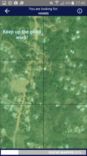
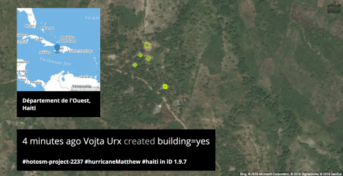
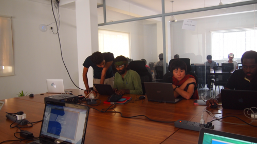
The Digital Humanitarian Network consists of many groups, from those that create maps, like Humanitarian OpenStreetMap Team, to those who curate social information like Humanity Road and Standby Task Force to bridging language skills via Translators without Borders. Ranging from small tasks to big asks, digital responders coalesce during an emergency. Over 2800 people contributed to Nepal Earthquake response with small tasks like MicroMappers by making quick decisions about text or images. These curated information insights were used by over 250 organizations to make decisions about various needs for the response, including damage assessments and aid distribution. The UGC could be created by anyone, but someone needs to parse the data, find the key points and match these core items to needs and actions. In reviewing the IP addresses of contributors, Qatar Computing Research Institute observed that the majority of these digital MicroMapper helpers were from northern countries.

For the Nepal Earthquake Response, over 7500 people contributed to improve OpenStreetMap in a short span of time. OpenStreetMap is a the Wikipedia of maps creating a large free and open dataset which anyone can use. Humanitarian OpenStreetMap Team (a VTC) creates tools and training to support mapping for humanitarian response and economic development. The Nepal earthquake response was co-lead by Humanitarian OpenStreetMap Team and Kathmandu Living Labs. Kathmandu Living Labs, started in 2013, creates local data and map solutions and partnerships, for Nepal. They have steadily built a local community of mappers trained in OpenStreetMap plus they mapped the country. Over the years, they have also built relationships with local partners from emergency responders to universities. When the Nepal Earthquake struck, they lost their office and a day’s work. Meanwhile, remote digital responders in the Humanitarian OpenStreetMap Team (HOT) community activated. HOT, with generous support of partners, obtained both pre- and post disaster satellite imagery to trace the regions of Nepal that might be affected.

Once Kathmandu Living Labs returned online, they worked very closely with the global and local community, which included responders like the American Red Cross, Canadian Armed Forces, Nepal Red Cross and Nepal Civil Defence. Mappers traced and created millions of edits for roads, infrastructure, helicopter pads, and potential emergency zones. The map products were then added to devices, printed and shared among responders to help with logistics and overall response. Humanitarians are collaborating side-by-side with digital responders and civic technology communities. The HOT Activation team advised the global community of mappers where to map based on official needs as directed by emergency managers as well as via Kathmandu Living Labs. Online communities are stitched together with local civic technology communities. They connected via skype, IRC (internet relay chat), Twitter, Facebook, G+, Instagram, mailing lists, websites, and wikis.

The networks, while informal, are all driven by the common vision of UGC for humanitarian response. Simply put, they move fast and have initiative to do the needful. For example, the OpenStreetMap Japan Foundation community translated the Guide to Mapping Buildings in Nepal from the Kathmandu Living Labs. So, one former disaster affected civic technology community activated to aid another transferring skills and supporting the digital need. No government or formal institution advised that this was required. People simply self-organized based on digital responder knowledge and the desire to help their digital neighbour. While the processes are not yet seamless, the gap between official and informal is closing with each response.

The World Humanitarian Summit, scheduled for May 2016, includes a consultation stream called “Transforming through Innovation”. The reports are glaring in their observations of NGO needs, power imbalances across the globe and, even, the desire for new technical skills to problem-solve. The Doha Youth Declaration for the World Humanitarian Summit consultation cited the need for more digital technology training, like the ones noted above. They cited a gap in training for civil society organizations across the globe, but especially in disaster risk areas. The Children and Youth Major Group has set up a working group to investigate implementation of digital training among other suggested outputs. In the months leading up to the summit there will be more reports analysis about innovation and scalability. Most of these are being shared widely via the WHS website or #ReShapeAid hashtag on twitter. But, the parallel system highlighting growth of digital responders can be found via hashtags like #civictech or website like Civicist or Code for All.

Despite the efforts of digital responders in the past five years, there is still also a gap in funding models. The skilled groups create tools, training and techniques which are increasingly invaluable to humanitarian needs. Yet, traditional donors do not consider them a right fit in NGO models, nor are they pure social entrepreneurs who can garner support from VCs or big business. A bright spot is that some NGOs are starting to get digital savvy by hiring data scientists/crisis informatics expertise (NetHope), GIS Professionals (eg. MSF, ARC) as well as software developers and social media curators. Plus there are programmes like Missing Maps that connect official organizations like HOT with MSF, American/British/Dutch Red Cross and CartONG to map the most vulnerable places in the world.

The Future

Community networks are blurred between offline and online. Social Media has become an essential service. People go online during all emergencies seeking information about “What is happening” and are their connections ok. Recently, the attacks in Paris, Beirut and Mali demonstrated that the pace and complexity of UGC is shifting more. The Facebook safety check is a tool that allows users to “check in” as “ok” in a specific affected area. This “check in” alerts individuals within a network. It is a newer feature widely used after the Nepal Earthquake. The surge of support to increase social sharing by key tools was demonstrated by online requests and the subsequent decision by Facebook to include Safety Notifications in conflict areas. After the Paris bombing, Facebook received overwhelming social response to make this feature available for more events across the world. Facebook agreed to open up this feature for more emergencies. There are questions about privacy of the individuals who use these tools during complex times. Data mining is part of Facebook’s revenue model with advertising. Digital Humanitarians are using social media tools for digital forensics to help affected communities and humanitarians. Concerns about who uses this data and for what purpose is ongoing. While the safety check is helpful on the surface, it could potentially put people in harm’s way.

Groupe Speciale Mobile Association (GSMA) reports cite the mobile use growth in the world. By simply overlaying a population map, it is clear that there is a correlation with youth populations. For affected communities and humanitarians alike, social media provides a massive shift in the information flow. New super skills will continue to build on the momentum to obtain and analyze aerial imagery for any digital response. Efforts will also continue to further the computational response by combining machine learning and human computing to parse massive datasets at high speed. It’s incredible to think about what will be possible in the very near future.

Three Challenges

  • At the moment, the vast majority of social media is available via public posts. But with huge growth in private Messaging tools like Whatsapp, how will digital response incorporate data from platforms like this?
  • In times of crisis, data becomes the lifeblood of managing humanitarian operations. But as access to data increases, how will people safeguard the privacy and security of those who need help?
  • What role should the main social platforms play during disasters? Can these social networks work together more closely to coordinate their responses?
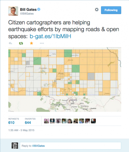
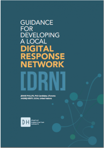
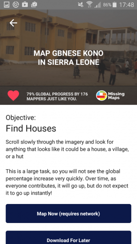
© Copyright 2016, All Rights Reserved