crisis

2May

Murmur: SMS, Badges and Location

Butterfly Bridges, created by Natalie Jeremijenko’s X-Clinic, have spun me into idea flurry. Last night I attended her Strategic Lab (Slab) presentation on Measuring the Common Good in Smart Cities. She is teaching and shaping biodiversity in new urban frameworks. Civic action activities like this and placemaking really show the potential of how we can build community in new and creative ways.

Murmur, SMS + Badges + Location

It is no secret that I’m location-obsessed. While maps are storytelling devices and are not an end in themselves, there is a connectivity to how location and storytelling provide us with common space. The Emergency Hack Labs project attempts to connect SMS, Open Badges and Placemaking to help people during times of emergency. The goals include providing volunteer engagement and peer-to-peer thanks. I wrote about this previously in Open Badges in a Crisis.

Map/Location projects with a true plan to connect the online to the offline are the most sustainable. It is more amazing some of the creative SMS campaigns that give voice. These projects during times of crisis are busy and important windows into what is possible and where some of the opportunities exist. But, we should be building them outside of emergencies and morphing them to local language and context.

Murmur is a Toronto project that uses SMS to connect people to location for stories. You can simply call a number listed on a sign in a particular place. The recording places a story or poem. The thing that has always struck me about this project is that people share and they learn the power of location. What if Murmur was installed in post-conflict zones or risk-prone regions? Local communities could curate the stories and teach in community centres. And, what if Murmur existed when a disaster or emergency happened? Would there be a difference in the community if people already felt comfortable with that style of non-threatening, trusted network program? It could start as a creative and art project, but then change gears to be a recovery and healing project to help with storytelling, remembrance and support. This is all theoretical. Technical, privacy and security issues would need to be addressed. But, expecting people to trust location and report stories with no historical community process for this is always a hurdle. Another scenario is: What if Murmur or its SMS kin was turned into a Volunteer peer-to-peer thanks model like Emergency Hack Lab?

Surely, this has all been done before? What examples can you share? I want to dig in more to understand how we can make location and online storytelling tools realistically connect online and offline during times of crisis.

So, thanks to Butterfly Bridges. With all this thinking, I am going to the park.

20Mar

Faith in Using Technology for Good

Have a little faith is what Neelley Hicks and the United Methodist Church remind us. Today they have launched their paper about their experiences in using Tech for Good.

“Technology is a tool for economic and social development that can aid in the reduction of poverty and change lives.” – Larry Hollon, Chief Executive, United Methodist Communications

I’ve talked with Neelly and her team a number of times throughout the last year regarding their Crowdmap. The experience taught me that we should all be partnering with faith-based organizations to help them learn and use technology for good. The United Methodist Church is using Ushahidi, Frontline SMS and other technical tools. Community organizers, especially CrisisMappers or ICT4D programme managers, know that the best projects include matching offline and online networks, training and planning, testing/iterating, having a strong infrastructure, taking care of your volunteers and doing something meaningful. As the United Methodist Church proves, faith-based organizations and technology are a great match. Neelley’s team taught me much about their sense of community and dedication to do great work. They have global, active community members who give their time and energy. Great community programmes should consider collaborating with local community centers (eg. Harassmap’s best practice) and local church groups (eg.United Methodist Church’s best practice).

ict4d-sustainability-3

Need convincing? Here are their #ICT4D Best Practice – 10 Tips: (follow their hashtag #ict4dBP)
#1: Put people first.
#2: Understand the local landscape.
#3: Design using appropriate tools.
#4: Prototype, fail, iterate, succeed.
#5: Build in #monitoring & #evaluation.
#6: Consider privacy & security.
#7: Enable user feedback loops.
#8: Remember community is critical.
#9: Build for sustainability and scale.
#10: Don’t lose sight of the bigger picture.

Congratulations Neelley and UMC team! Keep inspiring us to do good with purpose.

Resources

Get the full Using Technology for Good report.

The United Methodist Communiciations Press release.

19Feb

Open in Protest and Crisismapping

Protest and Crisismapping are intertwined with voice. I think conflict mappers, videographers, data analysts and storytellers are incredibility brave and important to our future. But, local knowledge, local language and local context must guide decisions. There are some tough questions to ask about what should be openly shared or why not have something as open data?

Videos, imagery layers, pictures, reports, maps, stories and datasets are used to both give voice and collect evidence on human rights violations. From the comfort of my home in Canada, I have not lived in times of civil war in Syria. I have not stood in the freezing cold in Kyiv alongside protestors. We can, in solidarity, write about it, share links online, become crisismappers (Digital Humanitarians), petition our governments, but for the most part, we are a world away. No matter how connected we are via the Internet, we can be equally disconnected.

On Protest

At Info Activism Camp, I joined the protest salon. Speakers discussed their activism in various global contexts. You can download and watch the discussion, read the protest mini-magazine and listen to the protest soundtrack.

There is a big difference in marching down to Queens Park (Toronto) vs. trying to feed your friends in Taksim Square in Istanbul or keeping your friends safe in Brasil. The stories of people’s lives, their efforts to protect rights and collect evidence gave me a profound backdrop for how I observe the world. The videos and livestreams from Ukraine tell a story of another country’s people in protest. There have been over 3 million views for the video I am a Ukrainian. The first time I watched it I cried. On the second view, it hit me how powerful video and Internet remains. Then and now: I fear for their safety.

Crisismapping Syria

Talking with Brown Moses, Women Under Siege Syria, or Syria Tracker, I have come to learn about the tenacity of humans and potential of digital forensics. These projects and their leaders are the forefront of asking questions: what should be published or not published. Their verification methods for video, pictures and reports are mapping new ground. They work very closely with people in the affected regions alongside global helpers. Brown Moses is meticulous in his analysis of social media (how Facebook is destroying History), weaponery and videos. Lauren Wolfe has built the Women Under Siege project to give voice to women who suffer brutal violence in times of war. Her methods in research, journalism, online engagement and verification highlight how a map can be one corner of a larger, more extensive project. Both the Syria Tracker and Women Under Siege teams do not publish all the details outright. They review, debate, curate and anonymize. Brown Moses has a unique talent of identifying and teaching methodology. These digital skills show us how crisismapping has evolved. Evidence and data collection happens in real-time. People are using these tools to make decisions. This is the nature of data and information. And while data can and has been used as a commodity and a power device, these types of projects show focus on those we serve – the survivors and the affected.

From Aleppo


“We struggle with this challenge, balancing between the imperative to do no harm with the virtues of transparency and openness.”

All of us seek information for evidence or even to help guide humanitarian decisions. This week First Mile Geo released it’s detailed case study on Aleppo complete with a set of open data. Collecting data about bakeries, locations and, potentially, movements in a conflict zone and then releasing that data will surely bring on questions. But, the First Mile Geo is already asking them with us:

Matt McNabb: But the principles underlying open data have their limits in conflict-affected areas, where the contest of information can –and often does –emerge more frequently to support actions that may have a deleterious effect on citizens’ safety or well being. Perhaps obvious to say, data in war can be a dangerous thing.

I firmly believe that the next future of open data is collected by citizens for whom the data is about rather than only stored in a government or business sanctioned data portal. We need both. The success or failure of Open Data will happen in the “majority world” (or as others call it the Global South or Developing world.) It is great to have Open Data events in over 110 places around the world on Open Data Day. One day is a start, but I think the penetration of Open Data will only happen if it follows the lead of OpenStreetMap. People need to be involved at a local level. Simply put: people don’t trust government and want to be part of the process (have agency over their data.) So, it is with this that I think methodology of First Mile Geo is at the forefront of combining offline community engagement (paper and pen) tied with maps to build local help. Crisismapping shows us that the raw questions alive in the field and being shared openly by folks like the First Mile team, Brown Moses, Syria Tracker and Women Under Seige. We need to consider what they have learned and how it can apply in conflict, crisis or developing areas.

Also see the Wired article on Mapping Aleppo

****
And now for more questions:

What does it mean to be “open” and “collaborative” in a conflict or crisis zone? What does it mean for protestors? When does the affected population get a voice in what video/picture or imagery gets used and for what means? What are the new ethics for the digital crisis? In January of this year, I joined a round table and said: we need an imagery code of conduct (for satellites and drones). I advised them that we can’t wait for 4 years of research. This is happening now. People are being affected now and digital humanitarians are having these discussions now. I shared some of the example discussions we have had within the Humanitarian OpenStreetMap Team. As security analyst Bruce Schneier rightfully points out, location is being used and we need to prepare for the new level of privacy and security discussions. While we race to share, collaborative and open up information, we need to build stronger data guidelines and data training.

Please go to: RightsCon and Responsible Data Forum to talk among peers. I’ll be watching via the Internet trying to catch snippets.

19Nov

Community brainstorming: The world needs more Crisis Mappers

Every organizer dreams of that perfect mix of location and glue for their work. There is this moment that an event gells and you can breath. Running the International Conference of Crisis Mappers pre-conference training was a true pleasure. I curated 4 tracks: mobile/security, maps, data and knowledge. Then, I recruited some of the best talent both already in the CrisisMappers community and groups/areas that there were gaps. Thanks to all my fellow presenters, trainers, ICCM organizers, sponsors (Ihub and Ushahidi) as well as all the participants.

We did not take full notes for all the amazing sessions. There were 105 participants split across all the various areas. It was an honour to have long time community members and new folks blend to build. The closing session was a group brainstorm. (See the ideas captured below.) To be honest, we were super exhausted from jetlag and learning. Here are some of the key questions or statements that everyone had at the event – in analog form. While is it a stream of conscious list, I think it speaks volumes about some of the other gaps / opportunities that we need to discuss. It is a window into a time and place.

On a more personal note, Ihub and Ushahidi gave us an amazing space and food sponsorship to help make this day a success. It was great to have the community together in the place that really ignited the movement. ihub is also one of my favourite event venues. It has this pulse that brings people closer together in a casual way. It was perfect for a very mixed crowd to really bond.


What questions do you think we should be discussing? What are some of the conversations you want to be having?

ICCM COMMUNITY

Community

  • Create a forum for humanitarian innovation forum
  • How do we reduce duplication of the same work by different organizations?
  • How do we collaborate with each other more?
  • How do we open up the crisis mappers community in Africa
  • Design challenges to make GIS Ouputs look good
  • How do we make innovation and its disruptive power more palatible to actors and governments in more politically/confict-affected settings
  • How do we involve community in mapping?
  • Find common projects so that we can collaborate
  • how do we connect crisis mappers to response organizations
  • Can we have a community code of conduct?
  • Capacity building team
  • Tech in itself does not solve any problems. We need to plug it in to existing processes
  • The world needs more crisis mappers
  • how do we make good community projects like the Sms in the neighbourhood yesterday work for larger areas?
    voice to the little community projects
  • post disaster anti-corruption management of funding and relief / rebuild “citizen” reporting
  • Cowboys : Humanitarians and Technologists

  • How do we involve community in mapping?
  • how do you build capacity of local community for learning how to read maps?
  • Humanitarians ethics in the information age

Data Ethics

  • What data ethics?
  • Privacy
  • Managing data security in a security-sensitive environment

Technical

  • Data analysts needed
  • Crisis mapping (is a social media)
  • When does geodata need data models? When can they be adhoc?
  • Best url for 101 on regular expressions?
  • Support mapping through satellite communication systems
  • How do we use the info we collect/ what is the purpose and impact?
  • Big data – identification and analysis
  • What is relevant data?
  • Why is there such a gap between web mapping and GIS on the desktop?
  • Data sharing and coordination
  • SMS or IVR for monitoring for education services (Primary) – eg. teacher attendance
  • Mobile delivery
  • How do you get structured data from a large illiterate user base speaking local dialects
  • How do we avoid stovepipes of innovation?
  • How do we leverage donor funding without competing for the same funds?
  • How can we use sensors?

Future

  • Will anyone their passport tomorrow
  • How to remember all the stuff we heard today?
  • Follow-up forums
  • Online training for this group
  • Psychological Crisis
  • Evaluate the context
  • how do you manage expectation of people who provide data on maps? (response capacity)
  • 1 kill = or does not equal 20 000 kills
  • How can crisis mapping contribute to reach out and help urban refugees?

Thanks everyone!

18Nov

Heart of the Matter

Matter. Difference. We use these words with varying degrees of weight, responsibility and, dare I say, ego. My inbox is full of collaboration. It is breathtaking to see governments, NGOs, technical communities and digital humanitarians work together. New ground has been broken. Alliances are being formed. People are contributing tech and analytical skills. Folks are trying to apply lessons learned.

Enroute to Nairobi for the International Conference of CrisisMappers I watched a film about humanitarian workers in complex conflict environments called Beyond Borders. There was a scene where “secret maps” caused a series of violent consequences.

Well, we don’t live in a “secret” map world right now. We live in a world that open communities, NGOs, and governments are truly seeking ways to build and to work with common goals and language.

Maps are love

In the past weeks and a half over 1100 amazing individuals have contributed over 1.7 million edits to the Humanitarian OpenStreetMap activation in response to the Typhoon Yolanda which struck the Philippines. There are a number of unsung heros who are volunteering hours to negotiate, to map and to plan using OpenStreetMap. From the folks who made it possible to get satellite imagery to those who have been tirelessly mapping. Andrew Buck and Pierre Beland have been spearheading the online coordination. They seem to be on every hour answering emails on the HOT mailing list or on the HOT IRC channel. Mapping Parties have been held around the world to support this. (Sam Leach’s post).

The American Red Cross joined the HOT community and board last night for a special call. They shared their story about how HOT OSM work is being used and what are some of the future requirements. Some of the organizations that got a shout out included Digital Globe, US Government, NGA and Mapbox. (With apologies if I am missing more, but others have provided imagery and fielded support.)

There was an ask to collect impact stories. Can you share yours?

Continents away I think about “matter”. For some of us, it is pure instinct. We spend our spare hours coordinating, documenting, sharing and trying to bridge this. Hats off to those who continue to “do” with Open.

15Nov

Stop Hacking without specing: a Top 10 needed

Here we are again. It is the day before a mass of hackathons occur around the world. It is exciting and important. Really. We all dream of using our knowledge and technical skills for a cause.

Earlier in the week I mentioned that we need to get more organized as a global community. Inspired by my colleague, John Crowley who wrote in Time Ideas: “Stop Catastrophizing Relief Efforts in the Philippines“, I ask that we please “Stop Hacking without Specing”. (Spec’ing = build a specification = a plan)

In the past week, I have had no fewer than 30 conversations with individuals, groups, governments and fellow organizers all about How to Help. They have been so amazing in their earnest need to include the technical community. We have come along way. Folks are asking tons of questions to prepare for the weekend. This is fantastic. I am so impressed with their fresh eyes, warm response and desire to make a difference.

I have two points to make: Organizers need to get connected/organized and we, collectively, need a TOP 10.

So you want to Hack for Emergency Software for change

Welcome, we are so excited for you to join us. Sorry that we have not got this quite sorted yet. This is new ground. We are all trying to build a common language. This is my short list of considerations:

Steps:

1. DO YOUR HOMEWORK

Please don’t hack or organize a hackathon without looking into what was done previously. Yes, of course, if you have a brand new idea: great! But first, check the following;

a. Random Hacks of Kindness website
b. Github
c. Google foo (trust me, it sometimes works)

2. ASK THE GLOBAL COMMUNITY

d. ASK our community – ask Geeks without Bounds, ask Random Hacks of Kindness, ask Crisis Commons and ask Crisismappers. We apologize in advance that we have not organized this yet. Trust me, we know this is an issue. Join us and help make it better. We have community skype windows open, just add me and I’ll introduce you – username- heatherleson

3. OPEN SOURCE IS LOVE, BUILD ON EXISTING SOFTWARE

We don’t need another Ushahidi, Sahana, SMSSync, Person Finder, etc.

(more on this below)

4. IF SOMETHING NEW, DOES it have an OWNER

…(And, will the owner be at your event) Serving an audience and having an owner be part of the design, testing and implementation process equals better software.

5. CHUNKS, DON’T TRY TO HACK THE OCEAN

Bring the problem down to hackathon size. The hackathon leaders need to really think about the problem statement and what is actually feasible to build or build-on during a weekend.

6. KEEP THE TECHS WANTING MORE

People are using their weekend to DO something. Every interaction is a gift. Honest. But, we want to build trust and have them know that their small contribution matters in the bigger picture. This is a really hard one. Honest. We know. Help everyone feel like they are part of the second or third wave of a very long process to build this collective effort.

7. IS IT SUSTAINABLE, USABLE

Who are you really serving if you build the shiniest tool that cannot be used in the field? Infuse your hack with local knowledge. Do they really have a need for an HTML5 enabled phone app when there is no CELL PHONE COVERAGE? Can you write a feature phone (DUMB PHONE) app?

8. Emergency Hack Lab

Emergency Hack Lab tackled the question of how to credential, task and thank volunteers in times of crisis. We hacked and built proto-workflow for the UN OCHA Noun Project sets to the Mozilla Open Badges programme. More details from session organizer Jessica Klein. You can add to this.

9. MAP instead?

Why not contribute to OpenStreetMap? The community has been mapping all week. Join the Humanitarian OpenStreetMap team and add to the map. Why is this important? UN OCHA, Red Cross and Doctors without Borders are already using it in the field and to inform their decisions. If you want to have an impact, map it!

Ok, that is part 1 – Helping the Hackathons in the interim. Yes, it is only 9 items. Please feel free to add something in the comments as I have probably missed one or 2.

***********

What is our top 10 Hacks that we need in Crisis/Emergency response

We are here again. How can we make sure that new hackathons, new techs learn from our experiences and build on efforts that already exist? I think that we have to have a TOP 10 wishlist that we know needs to happen.

I call on my fellow global community leaders to review and improve these. AND, I promise to make this a session at the International Conference of Crisismappers next week. I am sad that we are here again, but we deserve it. We need to get more organized and help the hackathon surge folks know what we need. Yes, we are still trying to figure it out, however, we have got to get better organized.

1. Humanitarian Exchange Language

NGOs and Governments need to share information better. UN OCHA is building this to help improve flow. This hack has been part of RHOK, International Space Apps Challenge and others. The code is online.

2. Google Person Finder

Ka-Ping Yee has worked tireless to document Google Person Finder. It has been deployed numerous times in the field and has been reviewed by many people in the humanitarian field. Help improve it.

3. Ushahidi

Bias alert: I am an Ushahidi former staffer and permanent fan girl. This has been deployed many times in the field. There are bugs. And, they have a new version. I believe that if we put our heads together with techs that we could make is so much better. This means that Ushahidi has to meet us half way (What are the top 10 hacks that people can do to help?) We need to see the power of citizen voices and how this project could help amplify real needs. Ushahidi can help on this. But, it needs community support. (love you guys)

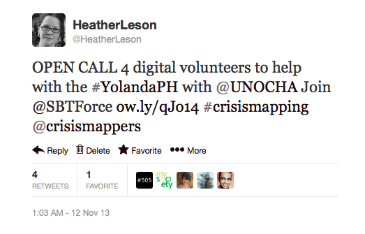
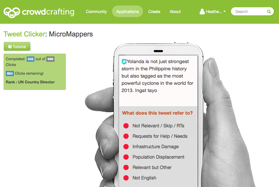
4. Micromappers, Crowdcrafting, SwiftRiver and Tweek the Tweet

All of these tools work on helping people manage signal to noise. The help volunteers get engaged and curate mass volumes of information. How can the technical community help?

http://micromappers.wordpress.com/

http://dev.pybossa.com/

https://github.com/ushahidi (swiftriver)

http://faculty.washington.edu/kstarbi/tweak-the-tweet.html

5. ALL YOUR DATA SETS BELONG TOO….

Last night I handed a population of Philippines dataset to Medicine Sans Frontieres. Some friends had scraped it from Philippine National Statistics website (http://www.nscb.gov.ph/activestats/). Not sure on the license, but folks need to have data with an open license to be able to layer it to maps. Why don’t we have a package of all the top datasets ready by country for emergency response?

6. MAPS ARE LOVE

We need common sharing among all the various map projects. And, a standard that lists all the active maps and provides interoperable layers so that people can pick and choose. When I say people, I mean those in the field who are helping.

Truly, we all dream of satellite imagery, citizen data, open data and sensor data on one map.
Maps are love. What can we do to make this happen?

I am purposely leaving the remaining 4 items empty. What is on your list?

…..Happy hacking! Really, I am so very excited to see techs using skills to help. Just be aware, you may get hooked and change your life like I did.

12Nov

Why we volunteer #YolandaPH

My spare time has been handed over to #YolandaPH response via the Digital Humanitarian Network. We are working in sprints on images and information (Tweets) to help sift data. This is all being added to map.

You can participate too
Screen Shot 2013-11-12 at 7.53.42 PM

The Humantarian OpenStreetMap Team and the whole OSM community are mapping infrastructure. It is amazing to observe. More on their efforts.

Quick observations and Why we Volunteer:

Diggz from Geeks without Bounds said it well: WE, the open mapping and volunteer community, have a lot to learn and re-learn. Those of us involved in the Haiti online response are already having flashbacks about duplication and confusion. It is bound to happen but it has improved some.

The tools still need work, but the purpose is clear: We know that together if we collaborate we may be able to help information and decisions.

I am seeing many many tweets asking for money. Some are legitimate, trusted organizations. Some are really unknown. I’ve seen people trying to sell stuff and say that they will give a percentage to aid. I’ve seen people offer to add their ‘brand’ to things. But, the overwhelming parts are the folks who have family there. Then, the pictures. All we can do is focus on our tasks.

Our community takes care of each other. We check in about rest, food and health. We welcome new people. We are all learning as we go.

All of us feel guilty for having jobs, personal needs and less time. I feel guilty posting this summary. But, I know that I need to tell what is happening. For us, we volunteer because we want to help in what we know we can do from our couches, our late night hub spaces and around the globe. We do this because we know that we can help. And, that our very small part might help a responder or a family know more details. We do this because we want to help those people.

Some examples of communication and tools:


My dashboard:
Skype, IRC and Micromappers (add to this tons of tabs)
Screen Shot 2013-11-12 at 7.28.52 PM

An example of the Micromapper tool using Crowdcrafting software. This was incubated as part of the OKFN Labs.(my employer)
Yolanda

Why does Crisismapping matter for Open Data?

Crisismapping inspired me to work in Open Data. The world needs it to make better decisions in crisis and beyond. This means using open data and open collaboration.

In times of crisis (see the Yolanda response) we all seek every type of open data set we can. We have governments, civil society, private sector and individuals all working together or in parallel. While the volunteering is very busy, I see it as the future for how we can get people to care about open data in sprints on any topic.

Back to it

7Nov

Putting on our Training Hats!

You’re invited to a skillshare pre-conference day with fellow Crisismappers. The International Conference of CrisisMappers (ICCM) will be held November 18 – 22, 2013 in Nairobi, Kenya. (About the full ICCM Conference.)

If you just want to attend the pre-conference training, you are very welcome! It is open to EVERYONE for a small fee ($50.00) paid to the ICCM conference. The trainers and speakers are local and national leaders. We hope you will join us at the ihub on Tuesday, November 19, 2013.

See more ihub and Ushahidi pics

About the Training

ICCM Training Day will have 4 tracks: Mobile/Security, Maps, Data and Knowledge. Each track will have sub-sessions and directed training. Participants can elect to join in one whole track or pick the individual sessions within the tracks. The purpose of this to give more hands-on training and allow folks to learn/share in smaller groups.

This is our ICCM Pre-conference day Draft Schedule. (Note it will be updated in the coming days)
We will add more details about the sessions and the bios of the speakers/trainers here.

How can I join?

To Join you can sign up for the Crisismappers Network, then click “ICCM 2013″. There you will find details about the registration login.

If you have any outstanding questions, send a note to Heatherleson @ gmail DOT com with the subject line – ICCM Pre-Conference Help wanted. Then, complete the registration. If you have questions about the full conference – please contact melissa at crisismappers dot net.

Outreach help wanted

We have more space open for the pre-conference training, Can you reblog my post or tweet this to your local communities? The sessions will offer a breadth of knowledge and expertise from security to research to map and data. We know folks will want to dig in and learn.


TWEET ME:

Join @crisismappers Pre-conference training- Nairobi – Nov. 19th. All welcome. Please register. Details: http://bit.ly/17fSDeE

********

Thanks a million to my fellow trainers, to ihub/ ihub research for hosting us and for Ushahidi (love you guys) for keeping us in food and drink!

11Jul

Grant GWOB

Geeks without Bounds needs your help. They want to hire a grant writer to take their team to the next level. Can you share a few dollars? I’ve co-hosted and participated in a few of their events. They are the real deal.

/GWOB Love

3May

Live Chat with the Guardian

The Guardian’s Anna Scott invited me to join the April 11th session on Making ICTs work for social justice and development. It was a vibrant discussion. Here are some of the best bits.

Some of my input:

A tool is only as good as the wider project: Successful projects need a mandate, a plan, a target audience and set metrics before any tool is applied. When people come to me asking about using Ushahidi to map their data, I ask them to prove to me why they need a map, and ask what their offline and online programme is outside of the technology.

The Guardian hosts live chats once a week on a wide range of topics. It was exciting to discuss topics ranging from security to project management. See future topics for the Global Development Professionals Network.

© Copyright 2016, All Rights Reserved