CrisisMappers

29Oct

How will Qatar prepare for Information Overload?

We are neighbours, no matter where we live. Being a new resident to Doha, I am grappling with a number of questions. These stem from working with humanitarian and crisis information for a number of years. Plus, it is part of my mandate at Qatar Computing Research Institute to help apply research and software to support local needs. We have learned much globally about emergencies. I’d like to learn more about how to help locally and who is keen to collaborate.

How will Doha and Qatar prepare for the upcoming information overload? What are the communications plans during an emergency? How will the public use or not use social media or new technology during an emergency? What are the information and technology needs in the GCC (Gulf Cooperation Council)? How does preparedness compare to other regions? How can citizens and communities prepare? How can Digital Humanitarians be of service? How would Digital Humanitarian community in Qatar differ? What are the training and technology needs of digital humanitarians locally? How can the local Digital Humanitarian community get more involved in the global community? How would Qatar Computing Research Institute’s work apply or not apply for emergencies in the region? What other types of research and/or software would serve the local responders and communities?

Gcc Government Social Media Summit

In September I attended the GCC Government Social Media Summit in Dubai. There were a number of presentations about preparedness and communications. I was interested to learn that in Dubai, every neighbourhood has a #hashtag. It is used for community activities but my colleague Ali Rebaie advised that this practice is also used for emergencies or resilience. This is something that happens around the world. Neighbours online are networks and information ambassadors locally (offline). This is invaluable. How can we apply this to Doha? Maybe because we are a smaller city and country, we organize primarily around #Doha or #Qatar. There should be tags for all social media platforms in multiple languages by districts and cities. By doing this, we can plan and share for communications.

The Qatar Red Crescent Disaster Management Camp in April 2015 provided great insights into how communication flows among responders. My observations found that people use WhatsApp to organize but are keen to investigate how social media might also be a communications channel. This participation has provided an impetus and goal to host a local social media and emergency meetups. Bringing responders and local enterpreneurs into the same space has started with the joint QCRI and Qatar Red Crescent Digital Humanitarian workshops. But, we do need to talk more about how social media will or won’t be a factor in Doha. How will people communicate during an emergency? How will responders work with them? At minimum, there needs to be local ‘information ambassador’ programme setup on WhatsApp. The more training the more ready we are for emergencies. The Qatar Red Crescent has been doing preparedness and resilience training in communities and with schools. Businesses may be thinking about text messages (SMS) during emergencies. But as a new resident working in these spaces, I do see opportunities to help.

CIvil Defense Exhibition and Conference


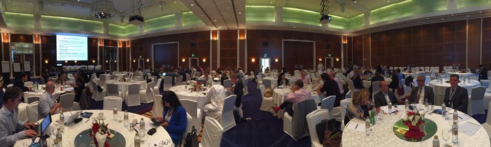
Civil Defense Exhibition and Conference
is hosting preworkshops on preparedness, community risk reduction, evacuation and infrastructure planning. All week for 5 hours a night I have joined about 60 people to learn from experts in the field. Participants are from across emergency response, civil defense, business and research. Questions have been fascinating. The earnestness to plan for all the stakeholders is very evident. While the mandate was not about ‘how communities will communicate’, it is very much on the minds of organizers and participants. All of this highlights the need for a more research on how will responders and communities work together.

IIEES (iran earthquake data)

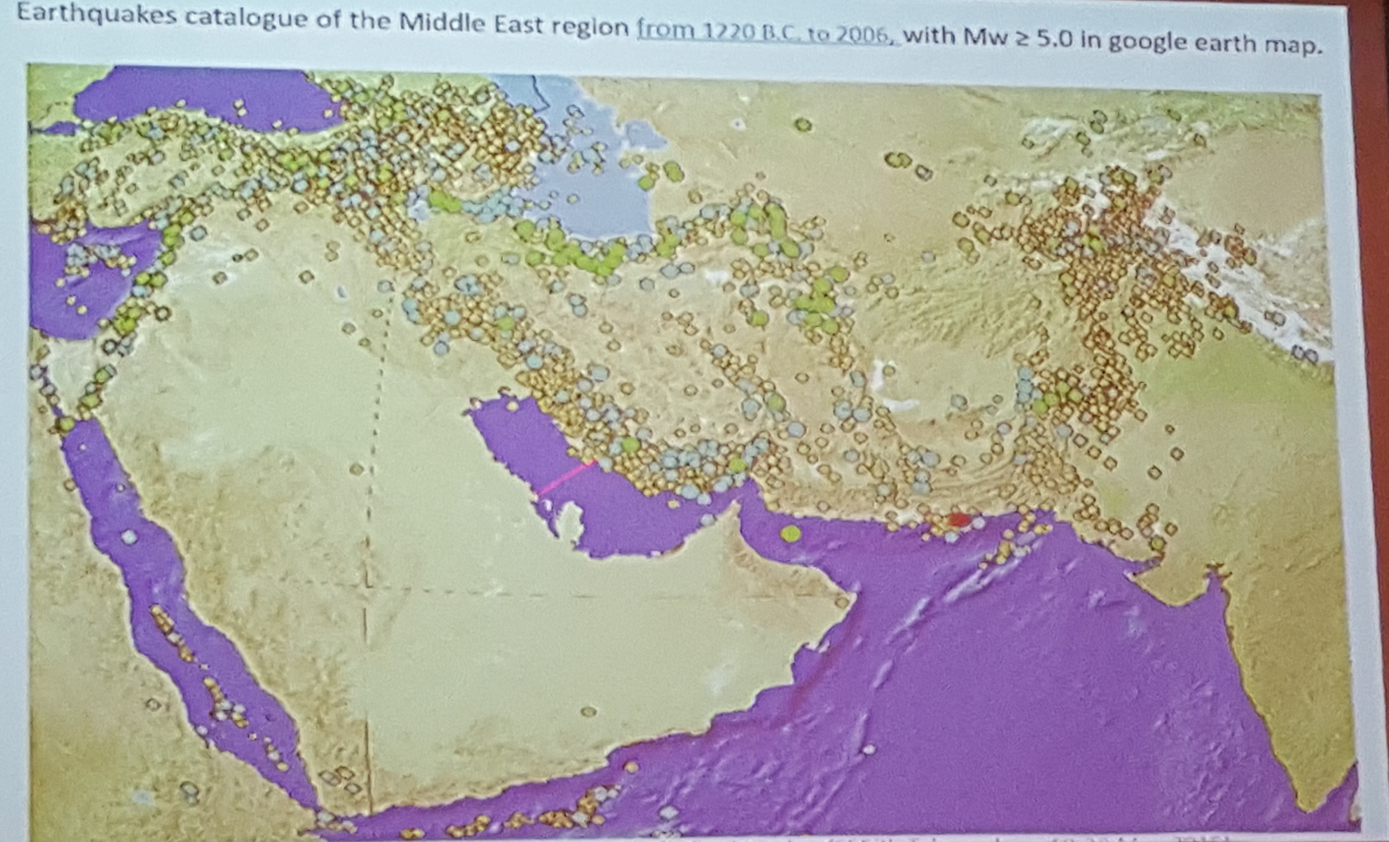
(Map presented by the Professor Zare of the International Institute of Earthquake Engineering and Seismology, IIEES (Tehran, Iran))

There is a large multilingual and high-volume mobile telephone penetration. I’ve found some success in building informal alliances and finding allies. In talking with many stakeholders, there is an enthusiasm to build more plans around communications and citizen engagement for preparedness. Who should I talk with who is interested in communications and emergencies in Doha, Qatar or the GCC?

23Sep

How to: A Digital Humanitarian Handbook

The Digital Humanitarian community is growing. In the Digital Humanitarian Network, there are many communities and organizations. Each of them have a specific set of skills to offer. While there are some guides for each of the groups, there is no free, online and translated course or introduction guide to help people get involved.

The purpose of this community driven project is to create a community sourced guide on github to help people learn from each other. This online handbook builds on the work of 1000s of community members who use their technical skills for good. Earlier this year, my colleague, Patrick Meier published his book about Digital Humanitarians. How can we widen the circle of participation and reach new areas to support resilience. For example, during the Nepal Earthquake response, the Japanese community created a translated version of the Nepal building guide for how to map in OpenStreetMap with Humanitarian OpenStreetMap Team. The Qatar Computing Research Institute and Standby Task Force response to the Nepal Earthquake had over 2800 participants from around the world. Our IP address report highlighted a participation gap in some regions of the world. At the recent World Humanitarian Youth Summit, I presented on why I think these digital skills are essential for the youth communities. Participants expressed an interest in learning and evolving this for their regions of the world.

During my time with the Qatar Red Crescent team at their annual Disaster Management Camp, we determined that core materials need to be translated into Arabic. I’ll be hosting local Digital Humanitarian training in Doha starting on October 1st. But what about the rest of the global community of civic tech and technical savvy communities. We hope that this will support our collective mission to encourage resilience and preparedness. And, while we are focused on crisis and emergencies, we think these core skills are very transferable to all the Sustainable Development Goals.

How to get involved

Or contact @heatherleson or @willowbl00 for help.

Draft Table of Contents

In the upcoming Digital Responders call in, we will review this draft table of contents. This will then be added to github to begin the curation process. Stay tuned for more details soon.

  • SECTION: Digital Humanitarianism Introduction
  • History of Crisismapping and Digital Humanitarians
  • Lessons and best practices
  • Code of conducts
  • Ecosystem: Working with Humanitarians and Contributors
  • Tools and Techniques overview
  • Examples by various topics – environmental, crisismapping
  • SECTION: SMS, social media and messaging (Whatsapp)
  • Digital Storytelling
  • Storify, Storiful,Blogging
  • Social media storytelling
  • SECTION: Community work
  • big tasks, small tasks
  • Microtasking 101
  • Software development in HFOSS
  • managing community lists
  • managing language and culture
  • SECTION: Data collection and analysis
  • Data Collection 101
  • sensors, social media, sms
  • Data Analysis
  • basic tools and techniques
  • SECTION: Verification
  • Overview and the Verification handbook
  • Verily and other tools
  • Visualization
  • charts, graphs
  • SECTION: maps
  • basic network maps
  • Geo for Good
  • Mapping 101
  • Mapping Google
  • Mapping OSM
  • Mapbox and Cartodb intro
  • Mapping ESRI
  • SECTION: Simulation 1: Teamwork and Roles (Global scenario)
  • How does coordination work during emergencies?
  • Coordination and community guidance
  • after action review
  • Simulation 2: Technique and mentoring (GCC scenario)
  • Technique testing
  • after action review
  • What to do with data after a project is done
  • How having a pre-existing community matters (KLL and Public Labs as examples)
  • Adversaries in digital space? InfoSec but also GamerGate
  • Digital colonialism
  • APPENDIX
  • Sample curriculums
  • Sample simulation templates and checklists

I envision that the manual will have chapters by country and region. The Taiwanese OpenStreetMap community, for example, might have specific examples and scenario templates for their region of the world. Plus, it is our hope that the manual will help people find best practices across the very topics and civic tech communities. We need to learn from each other. This Digital Humanitarian Handbook is for all of us to evolve and fork.

2Sep

The Next Stage of Digital Humanitarians

The World Humanitarian Youth Summit is in Doha, Qatar this week (September 1 – 2, 2015). Students and young people under the age of 30 joined from over 80 countries around the world. They are here to consult on a number of key issues creating an outcome document with key recommendations. Last night the drafting team was up until 5am AST working to compile all the brilliant ideas. This work will be submitted as part of the larger global consultations to Reshape Aid.

It was my honour to join the Transformation through Innovation panel to share some thoughts on how people could get involved as Digital Humanitarians and how they could learn and lead with these skills. During my talk, I share some thoughts on how we could challenge the future to get young people more involved all around the world. See my slides and detailed notes for more information.

**********

Thank you to Reach out to Asia, the World Humanitarian Youth Summit, and the Children and Youth Major group for welcoming me in their conversations. Also thank you to Chad Bevins, Mark Iliffe, Kathmandu Living Labs, Yantisa Akhadi, and Stace Maples for their photos about Humanitarian OpenStreetMap Team and OpenStreetMap activities around the world.

17Aug

Checking into the next stage of Digital Humanitarians

What does NEXT look like? Often as digital humanitarians, we are in the weeds of tasks. Many of us are still writing about the Nepal Earthquake Response and pondering how to improve and learn. With Humanitarian OpenStreetMap Team, I have my hands full with the Executive Director hiring process. And, at Qatar Computing Research Institute, we are testing a MicroMappers microtasking translation clicker with our friends over at Translators without Borders.

Last week Aspiration’s Willow Brugh held a casual Digital Humanitarian Checkin. In the conversation, each of the participants provided an update about themselves, their research, their technology and/or their digital humanitarian community. This checkin was special on a few fronts. First, many of us connect during times of crisis when we are super busy leading activations and onboarding new volunteers.

laptop


See the notes from our chats.
Some of the big themes were:

  1. Cross-community collaboration processes and tools
  2. Contributor Training and On-boarding
  3. Potential global meet-up for Digital Humanitarians

We need more regular activities to connect outside of emergencies. Thanks Willow for being the connector.

MicroMappers Global Map - Nepal Earthquake May 5, 2015
(Source: MicroMappers Global Nepal Earthquake response, June 2015. Created by Ji Lucas with Cartodb)

Digital Humanitarians in Qatar

I see blank spots on the map as a need to shift training and engagement. This is already happening, but for the next months, I am going to try to build a program in Doha. There are so many talented digital folks in Doha. I’d like to see them join the Digital communities. Certainly in speaking with some of them, I found a strong interest to learn.

World Humanitarian Youth Summit

If someone has the base digital skills, then they will remix it for local language, culture and needs. Plus, everything you learn is directly applicable to success in your career. Employees want digital savvy staff.

There is a buzz of activity in Qatar leading up the the World Humanitarian Youth Summit to be held in Doha on September 1 – 2, 2015. I’m hatching plans for digital activities to encourage more participation from Qatar residents and hopefully the GCC/MENA regions. Stay tuned.

28Jul

Matter – A Reflection on Volunteering

Motivation and matter: topics that drive me. (I’ve written about Heart and Fractual Matter before.) At Qatar Computing Research Institute, I’m creating programs to make it easier for MENA, GCC and Qatari folks to get involved in Digital Volunteering. The World Humanitarian Youth Summit is coming to Doha, so opportunity is knocking. I’ve also been thinking more about sustainable care-taking of “matter-ness” within the digital communities.

Volunteer motivation reasons frequently narrow down to “Matter” or “Inspired” or “Do Something” or “Knowing I can do something“. Today I got the “matter shivers” again. Tracy Glenn of SIDRA spoke at the Humanitarians of SIDRA event. Sidra is a Doha-based Medical and Research Center.

humanitarians of sidra

Tracy volunteered as a nurse in a Post Anesthesia Care Unit (PACU) in Rwanda and Palestine. During her time, she assessed and made recommendations to improve processes in the PACU. Her talk incorporated stories and photos from her experience in Jenin (Palestine) with the Palestine Children’s Relief Fund. Helping the vulnerable and train local capacity is a gift. Her honest integrity showed in every sentence and photo. By telling little snippets of life in the medical facility, she gave us a window in the healthcare needs in Jenin and the lives of the people she served. Listening to Tracy reminded me of all the other humanitarians in my life who have shared such heartfelt inspiration to volunteer with their skills. I hope that you get hear all their stories more. Healthcare professionals truly have this hardwired in their processes and networks. What can we learn from them? I certainly learned today from Tracy. (Thank you).

********

We’re all here coz we care

Jemilah Mahmoud on WHSummit (July 28, 2015)

Returning to my desk, I started to reflect on how to sustain motivation in a healthy way. As Digital Humanitarians, we go through phases of on/off. With every large response, I am seeing the wear on digital volunteers. Some of the people who gave their digital skills during the Haiti or Christchurch response contacted me just after the Nepal Earthquake and said sorry that they took a break but were ready to do something. Warmly I told each person how happy I was to hear from them.

We are so connected but disconnected some times in how we talk about volunteering. Every interaction is a gift. The human-ness of giving and volunteering is beautiful. We need to keep walking forward in cycles of sustainable patterns. And, when I say sustainable patterns, I mean – our own pace, taking care of ourselves, those we love and those who are allies. The saturation of energy during a response often takes weeks to months to recoup the cicada rhythms of spirit. Each digital organization needs this in their fabric.

The World Humanitarian Summit tweets via #ReShapeAid are a daily read for me. I try to read all the reports. And, I have had the pleasure to review and add some comments on how digital training needs to be part of the youth engagement strategy. But as we build programs and software to really ACTION the feedback of #ReShapeAid, how can we keep that pure sense of “motivation” and “matter” without burning out people. The intense purpose needs sunshine and a hug. I’m not trying to make light of the real focus we need to have. But with joy, the spaces (online and offline) that we create need to have human check-ins and keep humanity. This means inclusive, respectful, locally driven and with a spirit of “Matter” that does not crush the spirit or the action required. I think that digital spaces need to #Reshape too.

***

Dr. Mahmoud’s comment above on the same day as Tracy’s talk got me thinking. There are videos, photos and audio clips all around the internet. Many organizations have this as part of their use case narrative. But, what if there was a massive aggregator of videos, audio and photos on Why Humanitarian Volunteering Matters? Maybe we should start creating these items in all our digital spaces to honour the upcoming
World Humanitarian Day on August 19th this year.

18Jul

Visualizing flux: Time travel, torque, and temporal maps

[Cross-posted from Opensource.com. The original article was published July 17, 2015 as part of the OSCON Interview Series.]

Mapping communities in the open source space are growing as more and more people use maps for business and social change. Leaders like Aure Moser are providing spaces for people to learn and be inspired. Prior to her OSCON session and in the middle of a busy travel schedule, she shared some insights into the communities and her experiences.Aure Moser

Aure is a developer and curious cartographer building communities around code at CartoDB. Her background blends science and scripting, and includes a cocktail of conservation chemistry, eco-enthusiasm, education, and egalitarian tech activism.

Previously of Ushahidi and Internews Kenya, she’s been working in the open tech and nonprofit journalism space for a few years, and recent projects have had her working with mapping sensor data to support agricultural security and sustainable apis ecosystems in the Global South.

Q & A


You’re an active member of the OpenStreetMap Community, most recently volunteering at the State of the Map US 2015. What inspires you about this project?

I love OpenStreetMap, and am a happy recipient of a scholarship to speak at State of the Map in Buenos Aires (2014). It is the democratization of information that the OSM community embodies, and as a former librarian I have always loved the idea of open source web architects as intellectual social workers. We have such a beautiful opportunity as software engineers to learn from the iterative requirements and pace of open source and open data initiatives, and crowdsourced efforts to break from the exclusivity of proprietary platforms have a special place in my heart.

CartoDB has been a great support of open source, open data and open mapping. Can you share some examples about how you and your team incorporate this into your work?

Open source is so important to our mission to make maps more accessible, and it’s been essential for our stack development as we progressively learn from community requests and contributions. Our software is engineered for ease-of-use, and our GUI Editor interface is an effort to make mapping projects more accessible to non-GIS experts. Everyone should be able to map found, open, and personal data, easily. At the same time, we have almost all of the functionality accessibility in our editor, available via our open source libraries and APIs. We have Carto.js for making maps, Torque.js for time-series data mapping, Odyssey.js for building chapterized narratives on maps, Vecnik.js for vector rendering, as well as our Import, Map, and SQL APIs to facilitate easy and open map-building in code.

As part of the Community Team at CartoDB, I’m also pretty passionate about our education and outreach initiatives beyond just the open libraries and APIs. Giving talks and workshops on our software has encouraged us to build remote learning opportunities for our users, so we host webinars and themed workshops to support our community. The Map Academy is a series of online lessons in all aspects of mapping (not restricted solely to the use of our software) that we maintain to help mapmakers learn about Javascript, PostgreSQL, PostGIS functions, and the mechanics of map design. Likewise, we document and publish our workshops and talks on a public mini-site that we invite our community of educators and active users to contribute to in the course of their curriculum development.

When you were with Ushahidi, you spent time in Kenya. Building map projects and training in the Global South has some incredible stories and insights. It would be great to hear what you learned about the open source communities working there. And if you can, provide some examples of mapping projects in the Global South.

The level of creativity and resourcefulness in developing technology with profound infrastructural challenges was incredibly impressive and inspiring throughout iHub (Kenya) and in other locations. There can be a general insensitivity to the persistent challenges that people face when technologists provide open source products that only operate under optimal conditions and high-bandwidth communities. Working within other cultures and under the creative constraints of poor connectivity or strained infrastructure makes you think about how limited the value of your product is when it fails in the face of easy deployment and reuse globally. Those experiences were valuable to challenging my assumptions of digital literacy, and my flexibility in designing products of greater utility. I really benefited from exposure to Ushahidi’s team, and the network of subcommunities that their products have engendered. I’ve always been impressed by what Humanitarian OpenStreetMap Team and humanitarian teams globally were able to accomplish via crowdsourced efforts.

Having left Ushahidi, I’m still pretty involved with similar groups and had the opportunity to work with many journalists, especially at Internews-Kenya, on developing independent mapping projects. At Internews, I had the chance to collaborate on a map-interactive piece with Eva Constantaras and InfoAmazonia to explore narratives around mapping extractive industry in Kenya, called LandQuest. The project uses Jeo, a WordPress theme developed by InfoAmazonia out of Brazil, to make map mashups with blog-style publishing platforms, and the theming flexibility is pretty sweet. I’m also on the advisory board for an amazing group of technologists building toolkits for activists in the Global South called Beautiful Rising; among other resources, we support civic hacking and mapping projects to empower community builders and journalists.


How do you see the industry evolving over the next few years?

I think it’s safe to say that we will progressively collapse the distance between ourselves and our devices so “wearable” and “Internet of Things” futures are possible. I would say that we’re in a strange intermediary technology period now, where we’re pretty persistently developing products as an industry that provide a liaison to the future with a foothold in the past. In the same way that DVD/VCR combos were a short-lived intermediary before the obsolescence of the VHS player, we’re prototyping a lot of digital prosthetics that do things like put glasses on people who don’t need them or provide technical crutches to people otherwise unimpaired. I think there’s a great future in wearables and more fusion of physical technologies with software projects and dynamic mapping, and I’m pretty excited about it.

Since your talk is about time travel, where and when in time would you travel if you could?

Oh wow, such a great yet impossible question. There are a lot of historical events that I would naturally love to have witnessed if only for the Doctor Who/Quantum Leap opportunity to define what actually happened. I guess the less inventive and more egoistic part of me would love to have a Christmas Carol experience where I revisit or project potential outcomes in the Many Worlds possibilities of my future. So I’m pretty happy where I am, way beyond where I could be.

27May

Your Neighbour is Mapping

It has been a month since the Nepal Earthquake occurred and the digital humanitarian response has somewhat slowed. We remain mindful of the lives lost and potential long recovery period. As with every emergency now, global civic tech and mapper communities connect. In this case, our friends and colleagues at Kathmandu Living Labs were at the centre. This was the largest collective response as of yet. Time and analysis will tell us how effective we were and inform the next stages. The number of contributors across organizations with diverse skillsets/offerings ranged from 40,000 with Tomnod, 2800 with MicroMappers with leaders Standby Task Force (Over 170) and over 6000 with Humanitarian OpenStreetMap Team. We were inspired by the tremendous leadership of Kathmandu Living Labs(KLL) who together with partners like Humanity Road deployed of the most successful Ushahidi deployments for crisis response. KLL also co-lead the Humanitarian OpenStreetMap Team activation.

It is increasingly evident that the response changed Humanitarian OpenStreetMap Team’s (HOT) community. Now that some of us have had some time to rest and reflect, it is only fitting to host a session at State of the Map US on “Your Neighbour is Mapping“. How can we learn and foster civic tech like OpenStreetMap around the world, especially building on the lessons from the Nepal response? And, while we think big, consider neighbourhoods and regions that could be foster the civic tech spirit of OpenStreetMap in their own language, culture and traditions. Add to a discussion how to diminish the mapper gender divide.

State of the Map – US Tickets are going fast (Get yours by June 1st, 2015).

State of the Map – United States – Join us!

State of the Map – US, organized by the OpenStreetMap US team, will be held at the United Nations. There are many sessions about the wider OpenStreetMap community, technology and use cases. HOT members and community contributors will also be leading a number of conversations. Leaders include Dale Kunce, Kate Chapman, Mikel Maron and John Crowley to name a few. We are also planning on hosting a Birds of a Feather (informal chat) about HOT and the community.

Map icon

Together with Ivan Gayton of Medicine Sans Frontieres (MSF) I will be co-hosting a session. We want to spark a conversation on how we think OpenStreetMap’s community can get to the next 1 Million people. Both of us will ask: “what does implementation look like?” (even with the hard questions) There are many OSM and HOT projects around the world each with their own networks and activities. Drawing on his Missing Maps experience, Ivan will cite his lessons from hosting Missing Mapathons and field work in the Democratic Republic of Congo. (Missing Maps is a partnership between HOT, MSF and American Red Cross). As a HOT Board member for the past 3 years, I’ve been engaged in many community maturity and community growth conversations. We need to keep building on this. With some many contributors, how can we improve their experience and keep them engaged? To me, OpenStreetMap changed with the Nepal response. HOT changed. This a great thing. Now, how do we learn and pivot?

Elasticity means Local leads Global

Mapathons from Japan, Brazil, US, to Germany, local leaders in Nepal, and over 6000 contributors globally mapping using pre- and post-disaster imagery were just some of the community highlights from the Nepal response. Add to that all the guides on how to map everything from heliopads to Displaced Persons Camps and very detailed discussions about process, validation, imagery analysis and best practices for onboarding new mappers. HOT has always been an accordion growing for large activations and staying the course for longer term projects. We have learned so much about what we need to be more sustainable. This means everything from better training, software improvements, community microgrants, mentorship, and community development. But the biggest reminder is what makes HOT so special: yet again the local community, in this case, Nepal truly lead and taught the global ‘surge’ support what was needed while collaborating with official humanitarians.

We need to foster local OSM communities and civic tech hubs like Kathmandu Living Labs or HOT Indonesia. And, in doing so, recognize that we have so much to learn and share about global collaboration. It is my theory that much like the open data movement, these large pockets of OSM will alter the fabric to make it truly global. There were some moments during the Nepal Response when I would open my email and gasp with pride at the sheer collaborative generousity of people trying to map for good. The earnest spirit and drive to deliver the best maps to support humanitarians is what drives me to support HOT as their President. So, funders, (warmly) get ready for some phone calls. We need help to keep the momentum. And that we see how the lists of items that the new and long-standing contributors provided deserves consideration.

*******

OpenStreetMap in Qatar

I live in Doha, Qatar. When I moved here I researched the state of “open communities” and made some contacts. Some allies include QMIC, AL Jazeera, IctQatar, Qatar Living and Mada Qatar. At Qatar Computing Research Institute, we also use and create open source software, including OSM. The crux of the issue is that Doha is changing everyday and maps are quickly out of date. But, if there was a strong OSM community then this could be tackled. Countless times trying to explain location with faulty GPS or building names teaches me daily on the true need for OSM to grow here. There are people who want to build businesses on top of the base layer. They want the skills. Some immediate goals are to translate LearnOSM.org needs to be in arabic and begin hosting mapping parties. The good news is that I have located a small map cohort. Come September, we will host Maptime Meetings. Now, Doha does not need HOT for ‘economic development’ like other regions of the world, but Doha’s OSM mapping community will benefit from HOT tools and best practices.

(Map icon: by Mister-Pixel from Noun-Project)

20May

Advanced Research and Technology from WGET: ICT Humanitarian Innovation Forum

What are some of the research opportunities in Humanitarian Innovation? What are some of the “bright spots” to advance technology (new or existing)? The Working Group for Emergency Telecommunications (WGET) – ICT Humanitarian Innovation Forum was held in Dubai on April 29 – 30, 2015. While I curated the session, I was unable to attend at the last minute. Colleagues Larissa Fast and Rakesh Bharania kindly lead the interactive workshop about Communicating with Affected Communities. The WGET audience is a mix of technology companies, humanitarians, researchers and governmental (INGO, NGO, national and international) experts. This unique forum provided a chance to really drive conversations across disciplines.

WGET Session Description

Disaster-affected communities are increasingly the source of the “Big Data” that gets generated during disasters. Making sense of this flash flood of information is proving an impossible challenge for traditional humanitarian organizations. What are the next generation needs for actionable research and software in the fields of Social Data, Predictives and New Technology for Humanitarian response, especially focused on communicating with communities? This session will highlight the lessons learned from the Field while engaging participants in small group feedback sessions. Participants will be asked to discuss key topics such as research needs, opportunities and barriers. Suggestions will be documented and serve as an output from the workshop.

ABOUT WGET

UN OCHA created this Storify: Unveiling Digital Aid at the 2015 WGET
Find the WGETForum on Twitter
See the WGET website

WGET  Session

What are some of the opportunities, barriers and research needs to advance technology use for Humanitarian response?

Many of these answers are fairly common for any project: development and humanitarian. I am struck by the missing ‘step ladder’ to solutions. With the World Humanitarian Summit coming, will there be some technical meetings to brainstorm on ‘what does success look like’? Some of the work at Qatar Computing Research Institute, School of Data, Responsible Data Forum, Brck and various social entrepreneurs are tackling these issues. Are these tools and techniques reaching the right people?

I’ve taken the liberty to highlight the key points. The session format provided ‘headline’ topics. While these lists are missing some of the conversational context, it is our hope that it gives you a window into some of the knowledge shared. The next steps are truly up to all of us.

Some of the barriers cited for advancing use of technology include:
  • How they can operate best where countries declare an emergency. When a country says it does not have an emergency, it prevents from responding.
  • Lack of clear problem statement—lack of social data but we don’t know how more of it would solve a problem.
  • Predictive models need to be adaptive to be effective, which increases complexity
  • Funding, Costs
  • Restrictive government policies
  • Regulation/policy
  • No coordination of efforts
  • Trust (between organizations and people to organizations)
  • Decision-making triggers/timelines
  • Variety of platforms – trusted?
  • Connectivity
  • Disrupted networks in disasters, lack of real-time data
  • Energy infrastructure, energy resources, energy/electricity competencies
  • Duplication of efforts
  • Veracity of information
  • Risk of information to the organization
  • Reliability of data
  • Data protection,Data expiration
  • Do we want to use social data? What’s the point?
  • High noise-to-signal ratio
  • No one person(s) who across all organizations is collecting data and knowledge of all going on
  • Knowing information gaps and what is being collected and not
Opportunities in research and advancing technology:
  • Everyone is trying to solve this problem… need a forum where we can share
  • Financing mechanisms based on predictive data/forecast
  • Social media; good platform if we are able to use it properly.
  • Provide insight into an issue
  • Create awareness
  • Feedback mechanisms to better adapt humanitarian response to needs
  • Integration of public social media awareness for self-filtering (?) into preparedness campaigns
  • Move towards demand-driven assistance, especially in acute phase of relief
  • How can we evaluate effectiveness of our interventions.
  • Enhance decision-making
  • Mechanism/triggers for decisions
  • Common tools, analysis to collect intelligence from a variety of platforms
  • Base applications on HXL so that they can be aggregated (?), exchanged, consolidated
  • Share initiatives – communicate to all others so no duplication and extra effort
  • Crisis signal – see areas with coverage of phones etc. Provides useful info
  • To use the new social related applications which we are well known to send live videos of cases that required immediate action (e.g., Snapchat)
  • Using the UAVs to send live videos to people in charge of the humanitarian response
  • Pooling/sharing resources, risk, skills/analysis
  • Provide through experiments
  • Narrative to show need/value, lives saved/lost (feedback (positive/negative)
  • Provision better programmes by reacting to real time data
  • Evaluating effectiveness of our interventions real time
Some Brainstormed ideas:
  • Research: study on impact of tech on community resilience (net effect)
  • Create a humanitarian open-source community to develop tools based on social data
  • Accountability of quality
  • Insecurity of shared information
  • Escalation of information
  • Adaptive, real-time predictive models
  • Integrated social media filters for preparedness programs
  • ICT tech: problem statement, expertise in house (analysis, security), + tools
  • Data transfer agreement
  • Clearing and monitoring mechanisms for social data to make it trustworthy
  • Keep in mind the ethical considerations of ICT use in humanitarian
  • To allow models/analysis and define the way data can be used across agencies or specifically across the cluster

********


Thanks to UN OCHA (Patrick and Amanda) for supporting this session, Larissa and Rakesh for hosting in my stead, and Olly Parsons of GSMA for some great notes. And, thanks to all the participants for driving the conversations.

17May

Working with and through Volunteers

Alex Rose, Disaster Program Manager for the American Red Cross (ARC) gave an informal talk at Qatar Computing Research Institute (QCRI) about working with and through volunteers. QCRI is very keen to tie our humanitarian software research and development to real world work. Thanks Alex for sharing your work with our staff and summer interns.

Alex Rose on the ARC 5 Principles

As a humanitarian volunteer and staff, he shared examples about volunteer engagement and motivation. Los Angeles is a large city with a high risk of earthquakes. He wove stories of volunteers with examples on how resilient societies like Los Angeles can augment their communities with logistics planning and volunteer engagement. How would Doha prepare for a large emergency? Do we have the community infrastructure to support the official responders? Ironically, during the whole presentation, the fire alarms were being tested in the QCRI Tornado Tower offices. Always be prepared.

******

One of my goals in Qatar and the GCC is to create a Digital Qatar or Digital GCC network. We have much to learn from building online communities. Are we supporting healthy ecosystems for people to feel rewarded and motivated? Are we providing enough training and leadership? During the question and answer session, Mr. Rose encouraged both digital and local communities to provide letters of thanks and certificates for training. This is core to community growth and very much a best practice that we can all learn from the ARC. Based on the guest talk, I will be making some refinements to the MicroMappers process to incorporate better engagement.

******

Traveling to Doha

At QCRI, we encourage technologists, researchers, software companies and humanitarians to visit our offices and provide a session on your work. We want to encourage learning from practitioners and leaders to share their story. Please do drop me a line and I’ll make the arrangements.

5May

MicroMappers Nepal Response

[Cross-posted from MicroMappers.org, a project that I work on at QCRI]

A MicroMappers silver thread of goodness stitches this great world together. For the Nepal Earthquake response, Digital Humanitarians united from Doha to Bangalore to Phnom Penh to Auckland to Manila to Hong Kong to Vancouver to Buenos Aires to Mexico City to Boston to Stockholm to Bucharest to Nairobi to Capetown. Humanitarians and citizens of Nepal continue their efforts to deliver aid and support the country in the wake of the Nepal Earthquake. Our hearts go out to their important work and long road to recovery.

Over 2800 contributors reviewed tweets and images in the thousands to support humanitarians with information insights (See the full data below). All your ‘clicks’ and ‘decisions’ resulted in a highly curated dataset that was shared and incorporated into damage assessment decision-making by responders.

On behalf of the whole Qatar Computing Research Institute (QCRI) team and our partners the Standby Task Force, UN OCHA and GeoThings, we thank you for every moment you spent reviewing content, every time you shared this project with your networks and every time that you thought: “I can make a small difference in this world.” You took time away from your busy lives and families to help our neighbours who happen to be Humanitarians.

QCRI Senior Software Developer, Ji Kim Lucas, created this map to show the global MicroMappers Nepal Earthquake Response effort. We humbled by the power of community. Thank you!

MicroMappers Global Map

Media Coverage of MicroMappers

The MicroMappers project storytelling has been lead by my colleague, Patrick Meier. He is a true leader in the Crisismapping and Digital Humanitarian space. If you have not read his book about the growth of Digital Humanitarians, I highly recommend that you do so. It is all our story of how we aim to use technology for good. It is a true pleasure to work at QCRI with Patrick, Ji and the whole Social Innovation/Social Computing team. We are humbled by the 2800 contributors and how the media has embraced this story during such a difficult time for the Nepali people.

© Copyright 2016, All Rights Reserved